
 Русский
 English
 Español
 Deutsch


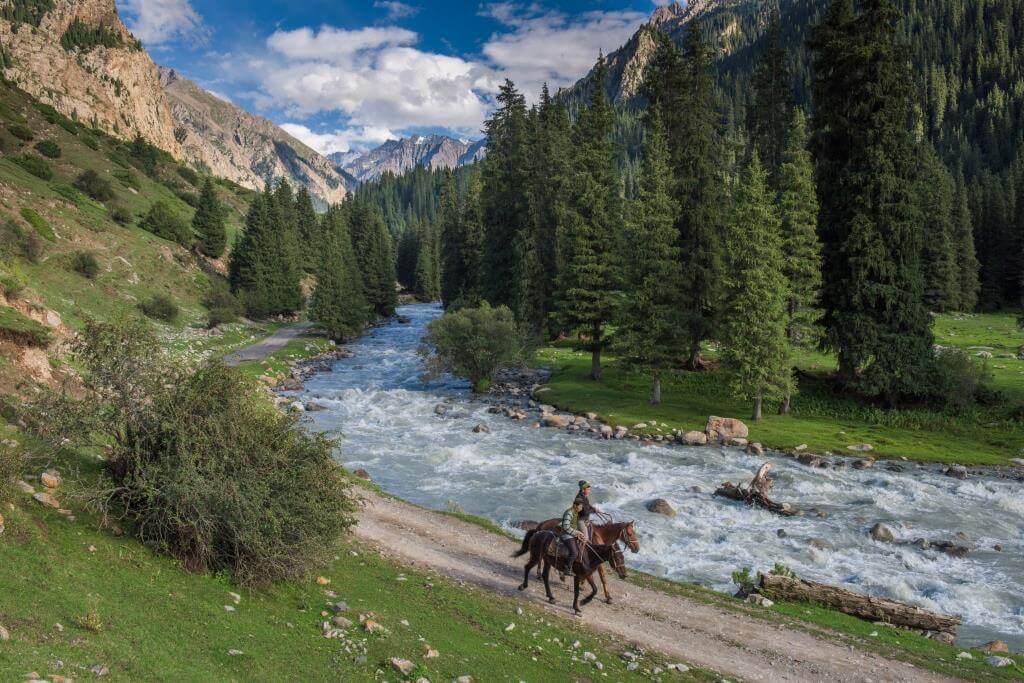
Le Kirghizistan est un pays situé entre les deserts Ouzbek, les steppes Kazakh, le Tajikistan et l’Ouest de la Chine. Sur le territoire Kirghize se trouvent les chaînes de montagne du grand Tien Shan et du Pamir avec leur plus hauts sommets mondialement connus comme le pic Pobeda (7439 m) et le pic Lénine (7134 m). Ces montagnes ont transformées le Kirghizistan en terre des glaciers, épargnées par la chaleur du soleil asiatique, avec des rivières de montagne bruyantes et ruisseaux vifs, d’énormes champs de neige riches en fleurs de prairies alpines, et de magnifiques vallées fertiles.
Le Kirghizstan, est extrêmement montagneux, peuplé à l’origine par des populations nomades. Ses habitants s’appellent les Kirghizes et parlent le kirghize, une langue turque. Sa capitale, qui est également sa plus grande ville, est Bichkek. La capitale du Kirghizistan n’est pas seulement le centre administratif du pays mais aussi le centre culturel et de l’éducation. La population de Bishkek avoisine 1 million d’habitants alors que la population totale du pays ne dépasse pas 4,7 millions d’habitants.
Le tourisme au Kirghizistan
Dans le cadre du développement moderne du Kirghizistan et de Bichkek, au fur et à mesure que les villes du pays se développent, on voit apparaitre les types de tourisme suivant au Kirghizistan: escalade, des programmes de piste, le ski alpin, la chasse, la pêche, la cueillette d’herbes médicinales, des excursions et parcours éducatifs le long du sud et du nord de la République avec le reste autour du lac Issyk-Kul et dans les montagnes. De plus au Kirghizistan on trouve le tourisme ethnographique (excursions en ski, traitement de l’asthme spéléo et d’autres maladies des voies respiratoires dans les grottes « Gros Sel » dans la vallée Chuyskaya et à “Chon-Sel” près de Kochkor), le traitement en altitude à Tuya Ashu, la chasse dans les fermes de chasse, la pêche, l’alpinisme, suivi de piste, cueillette d’herbes médicinales et de baies dans la montagne, la collecte de minéraux et ainsi de suite …
Le tourisme au Kirghizstan est idéal pour les touristes qui entreprennent un voyage, tout d’abord, pour acquérir de nouvelles connaissances sur l’histoire et la culture du pays, pour obtenir des impressions de rencontrer de nouvelles personnes. Sur son territoire il y a plus de cinq mille monuments historiques et culturels très anciens. C’est l’histoire du Kirghizistan.
La première ville visitée par les touristes au Kirghizistan est Bishkek, où se trouvent les principaux réseaux de transport : chemin de fer, aéroport, routes. Le tourisme au Kirghizistan est assez développé avec une population locale chalereuse, des hôtels confotables et de délicieux plat nationaux qui raviront ses visiteurs.
Histoire
La région correspondant au Kirghizistan fut peuplée aux xve siècle et xvie siècle par les Kirghizes, un peuple nomade turcique évoluant originellement, il y a 2 000 ans, dans le nord-est de la Mongolie et qui se serait d’abord déplacé vers le sud de la Sibérie entre le vie siècle et le viiie siècle, puis vers la région de Touva jusqu’au xiiie siècle. L’islam devient la religion principale de la région vers le xiiie siècle.
Au début du xixe siècle, le sud du territoire tombe sous le contrôle du khanat de Kokand. Il est formellement incorporé à l’Empire russe en 1876. La répression de plusieurs révoltes pousse un certain nombre d’habitants à émigrer vers l’Afghanistan ou la Chine.
En 1918, un soviet est fondé dans la région et l’oblast autonome Kara-Kirghiz est créé en 1924 au sein de l’URSS. En 1926, il devient la République socialiste soviétique autonome de Kirghizie. En 1936, la République socialiste soviétique kirghize est intégrée comme membre à part entière de l’URSS.
Lors des bouleversements politiques survenus à partir de la fin des années 1980 en Union soviétique, des élections libres sont organisées au Kirghizistan en 1991 qui voient la victoire d’Askar Akaïev au poste de président en octobre de la même année. Le pays change de nom et devient la République du Kirghizistan en décembre 1991, tandis que Frounzé, la capitale, est rebaptisé de son nom présoviétique, Bichkek, en février 1991.
Démographie au Kirghizistan
En 2016, la population du Kirghizistan était estimée à 5 727 553 habitants. La même année, 30,1 % avaient moins de 15 ans et 5,13 % plus de 65. Le pays est rural à 64,3 %, pour une densité de population assez faible de 29 habitants par km². La capitale, Bichkek, compte officiellement 589 000 habitants.
65 % de la population est d’origine kirghize, groupe ethnique turc présentant des influences mongoles et étant historiquement constitué de bergers semi-nomades, ils sont divisés en quarante clans. La plus grande minorité est celle des Ouzbeks (14,5 % de la population), principalement installés dans le Sud, suivis par les personnes d’origine russe (9,0 %, essentiellement dans le Nord), doungane (1,2 %), ouïghoure (1,1 %), tadjike (1,1 %), meskhète (0,9 %), kazakhe (0,7 %), ukrainienne (0,5 %) et coréenne (0,3 %). Il existe également de petites communautés d’origine allemande, mais la plupart sont parties dans les années 1990.
Près de 75 % de la population est composée de sunnites (islam), avec 20 % d’orthodoxes et quelques milliers de catholiques.
Langues au Kirghizistan.
Le Kirghizistan est l’une des deux ex-Républiques socialistes soviétiques, avec le Kazakhstan, à avoir conservé le russe comme langue officielle. Le pays a, en plus de celle-ci, ajouté la langue kirghize peu après l’indépendance en septembre 1991. Celle-ci appartient au groupe des langues turques. En 1924, un alphabet basé sur l’alphabet arabe fut introduit, remplacé par l’alphabet latin en 1928. En 1941, l’alphabet cyrillique fut définitivement adopté.
D’après un recensement de 2009, le kirghize se place en tête des langues parlées avec 71 % de locuteurs natifs, l’ouzbek en deuxième position avec 15 %, malgré son statut de langue officielle le russe n’occupe que la troisième place avec 9 % de locuteurs, les 5 % restants étant partagés par d’autres langues.
Toutefois, selon le même recensement, la langue russe est maîtrisée par 40 % de la population en raison du fait qu’elle constitue encore la langue des affaires et de la politique. On constate néanmoins une tendance à une arrivée de la langue kirghize sur la place publique. Longtemps considérée comme une langue domestique, la langue kirghize apparaît dans la vie politique et notamment beaucoup de délibérations parlementaires sont menées en cette langue.
Culture du Kirghizistan
Traditionnellement un peuple nomade, les Kirghizes restent attachés à ces traditions. Elles comprennent notamment les artisanats liés à la fabrication et à la décoration de la yourte, faite d’épaisses toiles de feutre. Le cheval occupe une grande place dans l’art, l’imaginaire et la symbolique collective. Ainsi le Kok borou et l’Oulak tartysh, deux variantes du jeu équestre du «bouc écorché», sont restés des sports très populaires.
Les premiers Jeux Mondiaux Nomades, qui mettent en valeur ces sports traditionnels kirghizes, se sont déroulés en 2014 au Kirghizistan; la deuxième édition des Jeux devrait également avoir lieu au Kirghizistan.
L’épopée et le poème mélodique improvisé sont les expressions artistiques par excellence. Ce dernier est accompagné au moyen d’un instrument à trois cordes, le komouz, et peut faire l’objet de joutes entre deux orateurs, les aïtysh. L’épopée Manas, phénomène littéraire par son volume et son emphase, transmise et enrichie sur plusieurs siècles par la tradition orale, fait la fierté d’un peuple qui connaît actuellement un processus de réappropriation de ses racines historiques et mythologiques.
Plus de détails: https://fr.wikipedia.org/wiki/Kirghizistan
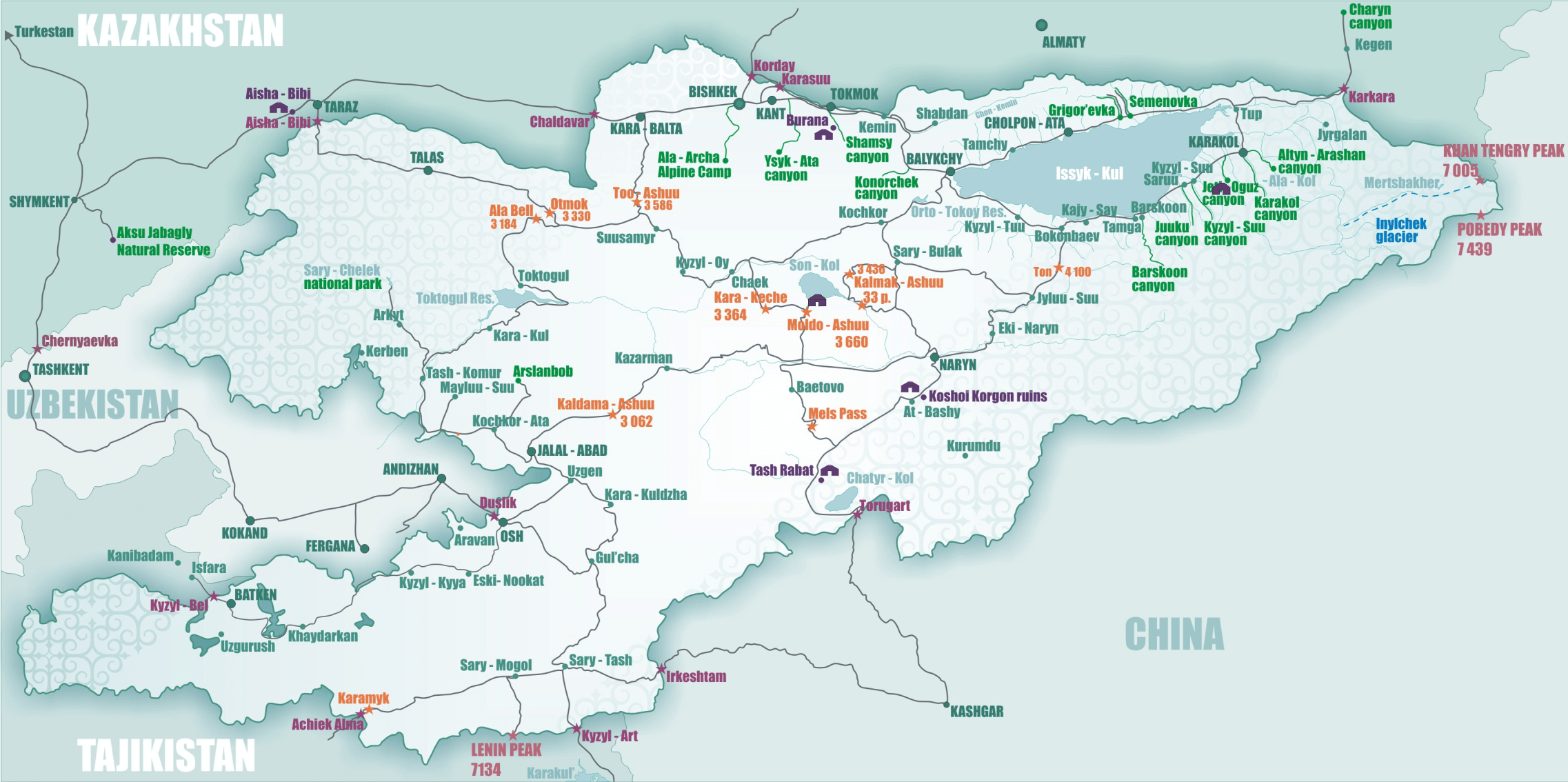
Geography of Kyrgyzstan
Kyrgyzstan is one of the most mountainous countries in the world – about 93% of its territory lies at altitudes above 1000 m above sea level, and the average height is 2750 m. The country is like a “fork” of the two largest mountain systems, reaching its maximum height (Pobeda Peak, 7439 m) in the vast Tien-Shan mountain site in the eastern part of the country, bordering China and Kazakhstan.
Through the entire northern part of the country, in the latitudinal direction, stretches nearly 600 km chain of mountain ranges of Ala-Toos or Alataus that in Kyrgyz mean “colorful mountains” – Terskey-Ala-Too (4808 m), Kyungey-Ala-Too (4770 m), the Kirghiz ridge (Kyrgyz Alatau , 4855 m), Talas Alatau (4,251 m), Suusamyr-Too (3828 m), Karakolsky ridge (4273 m) and others. They form the northern mountainous frontier of the country, dividing the territory of Kyrgyzstan from the arid deserts and Moyynkum Saryesik-Atyrau. The southern part of the country form a powerful ridges Chon-Alai (Trance-Alay) mountain system, which is the second highest peak in Kyrgyzstan – Lenin Peak (7134 m), and the border with China back Kakshaal-Too.
The central part of Kyrgyzstan formed ridges and spurs of the grand mountains of Tien Shan (“Celestial Mountains”) – Jeti (4896 m), Moldo-Too (4099 m), At-Bashy (4786 m), Borkoldoy, Chatkal (4503 m) and Alai (5259 m) mountain ranges, stretching from west to east over 2400 km (continuing on the territory of China , Tajikistan and Uzbekistan ). Moreover, from the main axis of the Tien Shan to the north and south moves a lot of high ridges (Suusamyr-Too – 3828 m, Ferghana – 4692 m, etc.) and arrays (Ak-Shiyrak, etc.), forming a powerful mountain sites. Between the ridges are large tectonic depressions Susamyr, Srednenarynskoy, Turfan, Hamiyskoy, Ili, Chu, Toktogul and Talas basins, and Lake Issyk-Kul, Chater-Kul, Son-Kul, etc.

In the eastern part of Central Tien-Shan Mountains, within the vast mountain site, clearly expressed in two converging bands of mountain ridges, separated by a sequence of valleys and basins, elongated in the latitudinal direction. In the composition range Kakshaal-Too rises the highest point in the whole range – Peak Pobeda (7439 m). And nearby, in the ridge Tengri-Tag, is another seventhousander – Mount Khan-Tengri (Lord of Heaven “, 7010 m), considered a symbol and a business card of the Tien Shan. The lowest point of the country lies on the banks of the river Kara (Kara-Darya 132 m), thus differences in elevation in the territory of Kyrgyzstan reaches 7300 m.
Mountain areas are covered with a powerful glaciation – there are about 8000 glaciers with a total area of more than 8100 km (4% of the territory), ranging from the dizzying heights up to 2900 m above sea level. The largest glacier country – Inylchek (Enilchek, North and South), which together with the adjacent ice fields reach an area of 800 square meters. km. For the highlands is characterized by glacial landforms (cirques, ditches, troughs, etc.), the slopes of ravines are covered with numerous dunes, and the bed of the valleys – thick moraine deposits of the glaciers. Wide-spread high-altitude permafrost, which covers the slopes and the bed almost 60% of the high mountain valleys. Also, frequent small alpine lakes and even swampy areas. From the mountains runs more than 12000 rivers and streams that feed as many lakes and rivers of Naryn, Talas , Ili, Chu, and Aksu.
A characteristic feature of the local landscape is the alternation of high mountains and deep intermontane basins, forming a labyrinth. Thevegetation in the piedmont plains are mostly desert and semi-desert, in the mountains – mountain steppes and forests, alpine meadows and meadow-steppe. Moreover, in the territory of Kyrgyzstan practically all natural zones of northern hemisphere of the planet – can be found here and thick mountain forests and arid steppes, deserts, including alpine and tundra, floodplain meadows and mountain valley swamps (saz), all of which are often removed from each other at a distance of no more than a couple-three hundred meters. Flora of the country’s population of about 4200 species of higher plants, and fauna – some 500 species of vertebrates, of which 86 – mammals, more than 50 species of fish and about 360 birds. For agriculture, suitable only 7,3% of the republic.
Kyrgyzstan Terrain
Kyrgyzstan – the mountainous country. Most of Kyrgyzstan is a mountainous system of the Tien Shan, and only the extreme south-west is in the Pamir-Alayu. High point – Victory Peak, or Dzhengish-Chokusu (7349 m), located in the Tien Shan in the east, on the border with China.
Many of the ranges of the Tien Shan – Talas Alatau, Kyrgyz, Kyungey-Ala-Too, Terskey-Ala-Too and others – are predominantly sublatitudinal. Big Fergana mountain range is oriented from northwest to southeast, and the ridge Kakshal-Too – with the south-west to north-east (along the border with China), with a single pass in the Tien Shan Torugart (3752 m). Between the ridges Kyung-Ala-Too and Terskey-Ala-Too is intermontane basin, the bottom of employing a large lake Issyk-Kul, the so-called “Kyrgyz Sea”. To the north of the Kyrgyz Range located submontane Chu depression, mastered and most densely populated part of the republic. Extensive Fergana valley enters the limits of Kyrgyzstan , only the peripheral parts. In the Kyrgyz part of the Pamir-Alai dominated sublatitudinal relief elements – Alai Range, the Alai Valley, Turkestan and Trans-Alay (highest point – Lenin Peak, 7134 m) ranges. In the eastern part of the Trans-Alay Range Pamir highway intersects with the Kyzyl-Art Pass. In the upper tier of the mountain glaciers developed. The snow line is located at altitudes of ca. 3 km to the peripheral ridges and 4,0-4,5 km – on the internal ridges. We present different types of glaciers. The largest of them – dendritovye (Inylchek length of 59,5 km and North Inylchek – 38,2 km), with a few ice-flows. In addition, widespread valley, cirques and hanging glaciers, as well as characteristic of the Tien Shan glaciers are flat tops. Tien Shan is rich in water resources and is a major supplier of water for the surrounding arid plains.
Climate and Water of Kyrgyzstan
Climate
Kyrgyzstan has a continental climate. The western and northern slopes of the mountains receive more precipitation. Precipitation increases with altitude up to 5000 m. At higher altitudes precipitation falls as snow, and even in summer frosts are possible. Average annual precipitation on the northern slopes of ca. 750 mm in the south-western slopes of the Fergana Range – 950 mm, and the north-east – 230 mm.
Average January temperatures range from -2 ° to -8 ° C in the valleys and from -8 ° to -20 ° C in a medium-altitude mountains. In high average January temperature – approx. -28 ° C. In many parts of Kyrgyzstan , except the high mountains in winter are often thaw. Summer is hot and dry, with average July temperature in the valleys of 20-27 ° C In the mid 15-17 ° C, while in the high 5 ° C and below.
Water
Within the limits of Kyrgyzstan there are more than 3000 lakes, including the picturesque lake Issyk-Kul – one of the deepest in the world (maximum depth 668 m). Large rivers – Chu, Naryn and Talas – originate in the highlands. Chu occurs in the north, to her during 145 km of the border of Kyrgyzstan and Kazakhstan . The Naryn River, merging with the district. Kara Darya, forming the Syr Darya, which flows eastward into the Fergana Valley. Talas drains the north-eastern Kyrgyzstan.
Plant and animal life in Kyrgyzstan
Flora of Kyrgyzstan’s very diverse, not less than 1 / 4 of all species are endemic. For the Tien Shan is characterized by a forest belt of the Tien Shan spruce, which replaced the above thickets of juniper and subalpine meadows. In the northern mountains framing the Ferghana valley in places preserved forest nut (walnut). In high prevalent sub-alpine and alpine meadows used for many years under the summer pastures for sheep. At the highest levels of the relief is widely developed subnival zone with rubble heaps and snowfields. Herbaceous plants there have been very few, are common mosses and lichens.
In the foothills of distributed ephemeral desert, semi-deserts and dry steppes above shifting shrubs and woodlands.
In the highlands inhabited by ibex “teke”, mountain sheep “argali”, snow leopard, stone marten, red wolf, gray and red mountain marmots. In the forest mountain belt distributed deer, wolf, weasel, wild boar, lynx, brown bear, fox, marten. For steppe highland areas and the adjacent plains are characterized numerous species of rodents, including yellow, gopher, great coney, red-tailed gerbils, various reptiles, from ungulates – gazelle, birds – partridge, bustard, etc.
La région correspondant au Kirghizistan fut peuplée aux xve siècle et xvie siècle par les Kirghizes, un peuple nomade turcique évoluant originellement, il y a 2 000 ans, dans le nord-est de la Mongolie et qui se serait d’abord déplacé vers le sud de la Sibérie entre le vie siècle et le viiie siècle, puis vers la région de Touva jusqu’au xiiie siècle. L’islam devient la religion principale de la région vers le xiiie siècle.
Au début du xixe siècle, le sud du territoire tombe sous le contrôle du khanat de Kokand. Il est formellement incorporé à l’Empire russe en 1876. La répression de plusieurs révoltes pousse un certain nombre d’habitants à émigrer vers l’Afghanistan ou la Chine.
En 1918, un soviet est fondé dans la région et l’oblast autonome Kara-Kirghiz est créé en 1924 au sein de l’URSS. En 1926, il devient la République socialiste soviétique autonome de Kirghizie. En 1936, la République socialiste soviétique kirghize est intégrée comme membre à part entière de l’URSS.
Lors des bouleversements politiques survenus à partir de la fin des années 1980 en Union soviétique, des élections libres sont organisées au Kirghizistan en 1991 qui voient la victoire d’Askar Akaïev au poste de président en octobre de la même année. Le pays change de nom et devient la République du Kirghizistan en décembre 1991, tandis que Frounzé, la capitale, est rebaptisé de son nom présoviétique, Bichkek, en février 1991.
Langues au Kirghizistan.
Le Kirghizistan est l’une des deux ex-Républiques socialistes soviétiques, avec le Kazakhstan, à avoir conservé le russe comme langue officielle. Le pays a, en plus de celle-ci, ajouté la langue kirghize peu après l’indépendance en septembre 1991. Celle-ci appartient au groupe des langues turques. En 1924, un alphabet basé sur l’alphabet arabe fut introduit, remplacé par l’alphabet latin en 1928. En 1941, l’alphabet cyrillique fut définitivement adopté.
D’après un recensement de 2009, le kirghize se place en tête des langues parlées avec 71 % de locuteurs natifs, l’ouzbek en deuxième position avec 15 %, malgré son statut de langue officielle le russe n’occupe que la troisième place avec 9 % de locuteurs, les 5 % restants étant partagés par d’autres langues.
Toutefois, selon le même recensement, la langue russe est maîtrisée par 40 % de la population en raison du fait qu’elle constitue encore la langue des affaires et de la politique. On constate néanmoins une tendance à une arrivée de la langue kirghize sur la place publique. Longtemps considérée comme une langue domestique, la langue kirghize apparaît dans la vie politique et notamment beaucoup de délibérations parlementaires sont menées en cette langue.
Culture du Kirghizistan
Traditionnellement un peuple nomade, les Kirghizes restent attachés à ces traditions. Elles comprennent notamment les artisanats liés à la fabrication et à la décoration de la yourte, faite d’épaisses toiles de feutre. Le cheval occupe une grande place dans l’art, l’imaginaire et la symbolique collective. Ainsi le Kok borou et l’Oulak tartysh, deux variantes du jeu équestre du «bouc écorché», sont restés des sports très populaires.
Les premiers Jeux Mondiaux Nomades, qui mettent en valeur ces sports traditionnels kirghizes, se sont déroulés en 2014 au Kirghizistan; la deuxième édition des Jeux devrait également avoir lieu au Kirghizistan.
L’épopée et le poème mélodique improvisé sont les expressions artistiques par excellence. Ce dernier est accompagné au moyen d’un instrument à trois cordes, le komouz, et peut faire l’objet de joutes entre deux orateurs, les aïtysh. L’épopée Manas, phénomène littéraire par son volume et son emphase, transmise et enrichie sur plusieurs siècles par la tradition orale, fait la fierté d’un peuple qui connaît actuellement un processus de réappropriation de ses racines historiques et mythologiques.
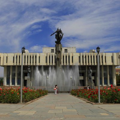
Bishkek – the capital of Kyrgyzstan
Nice green city with a number of parks, soviet time monuments and combination of old houses, and soviet buildings. Many of exciting sights located outside Bishkek including ruins of ancient cities and beautiful valleys of Kyrgyzskiy Ala-Too.
The capital, Bishkek, is situated in the Chui valley in the north of the country. It was founded in 1878 and originally was called Pishpek, which is the name of the wooden paddle with which the Kyrgyz make their kymyz (kumiss – fermented mare’s milk), the national drink. Later, during the Soviet Union period, it was named Frunze after the famous Russian General Mikhail Frunze. At the time of Independence in 1991, it was renamed Bishkek.
The city has been influenced by the Russians from the beginning, and actually more or less built by them. Most of the buildings you see today are built in a typically Soviet architectural style, and the trees in the parks, boulevards and alleys are watered by a system of canals built by Russians. Those boulevards and parks make this a pleasant city to live in, as they provide total shade in summer, when temperatures may reach 40 degrees Celsius (105 F), and the open canal system also helps to keep the summer bearable. Bishkek is known to be one of the greenest cities in Central Asia as a result of this planning.
Bishkek cannot claim to be one of the major cities of the world, like London, Paris or New York. It is, however, the capital city of Kyrgyzstan and does have a number of important and interesting buildings, monuments, parks, museums, galleries, theatres and other places worth seeing or visiting.
- Ala-Too Square is the central square in Bishkek, Kyrgyzstan. The square was built in 1984 to celebrate the 60th anniversary of the Kyrgyz SSR, at which time a massive statue of Lenin was placed in the square’s center. The statue of Lenin was moved in 2003 to a smaller square in the city, and a new statue called Erkindik (Freedom) was installed in its place.
- Osh Bazaar. This is a true oriental bazaar that you will not see anywhere else, because it reflects the true nature and coloring of the nation. Entering this market, you find yourself in the past, here, as many years ago, it would seem, nothing has changed, crowded market, envelops buyers with the cloud of spicy aromas. Dozens of unique spices and seasonings: basil, dill, parsley, coriander, celery, onion, garlic, thyme, cumin, red and black pepper, dried tomatoes, barberry, black, zira, bunium, sesame. About six dozen species and varieties of spices and seasonings can be counted on the shelves. Vendors vying offer raisins and dried apricots, almonds and pistachios, walnuts and peanuts.
- Victory Square. The 9th of May, 1945 is the Victory of Soviet Union over Fascist Germany in the Great Patriotic War started on 22nd of June, 1941. The Memorial was constructed in 1985, to commemorate the 40th anniversary of the Victory. Three curved arcs represent a yurt. There is a statue of Kyrgyz woman inside the construction. She (mother, wife) is standing under a tunduk in the form of a funeral wreath at the eternal flame, waiting for her son / husband, who never returned home from the front. According to the tradition the memorial is must-to-visit place for all the wedding ceremonies.
The Ala Archa National Park
The Ala Archa National Park is an alpine national park in the Tian Shan mountains of Kyrgyzstan, established in 1979 and located approximately 40 km south of the capital city of Bishkek. The park, which includes the gorge of the Ala-Archa River and the mountains surrounding it, is a popular destination point for weekend picnicers, hikers, horse trekkers, skiers as well as mountain climbers looking for challenging ice, rock and mixed routes. The park is open year round, although the most popular season is late summer and early fall.
In Kyrgyz, the archa, which gives the park its name, is a bright or many-colored juniper which the Kyrgyz people have traditionally held in special esteem, using smoke from its burning wood to chase away evil spirits. However, the archa is not supposed to be planted near the home, because it is believed gradually to sap the energy from human beings living close-by.
The park covers about 200 square kilometers, and its altitude ranges from about 1,500 meters at the entrance to a maximum of 4,895 meters at Peak Semenova Tian-Shanski, the highest peak in the Kyrgyz Ala-tau range of the Tian Shan. There are more than 20 small and large glaciers and some 50 mountain peaks within the park. Two smaller rivers, the Adygene and the Ak-Sai, originate from these glaciers’ melting waters. The Adygene gorge is a beautifully wooded valley, with waterfalls, springs and abundant trout. A small reservoir on the Kargay-Bulak river was built to study the Amu Darya trout. Other wildlife includes the very rare snow leopard (in Kyrgyz: « ilbirs ») on the alpine meadows and snowfields above 2,500 m elevation, wild goats, roe deer and marmots.
Burana Tower
The Burana Tower is a large minaret in the Chuy valley in northern Kyrgyzstan. It is located about 80 km east of the country’s capital Bishkek, near the town of Tokmok. The tower, along with grave markers, some earthworks and the remnants of a castle and three mausoleums, is all that remains of the ancient city of Balasagun which was established by the Karakhanids at the end of the 9th century. An external staircase and steep, winding stairway inside the tower enables visitors to climb to the top.
The tower was originally 45 m (148 ft) high. However, over the centuries a number of earthquakes caused significant damage to the structure. The last major earthquake in the 15th century destroyed the top half of the tower, reducing it to its current height of 25m (82 ft). A renovation project was carried out in the 1970s to restore its foundation and repair the west-facing side of the tower, which was in danger of collapse.
The entire site, including the mausoleums, castle foundations and grave markers, now functions as museum and there is a small building on the site containing historical information as well as artifacts found at the site and in the surrounding region.
Legend
A legend connected with the tower says that a witch warned a local king that his newly-born daughter would die once she reached the age of eighteen. To protect her, he built a tall tower where he sequestered his daughter. No one entered the tower, except the daughter’s servant who brought her food. The daughter grew up alone and became a beautiful young lady. One day, however, a poisonous spider was hiding in the food brought by the servant. The spider bit the girl, and she died in the tower, at the age of eighteen.
Cholpon-Ata Petroglyphs, Kyrgyzstan
Cholpon Ata PetroglyphsSome unique ancient monuments are located on territory of Cholpon-Ata town. There are Bronze Age settlement and ancient sacred place under open sky with stone painting. Andronic tribes or Arian tribes (the middle II millennium – VIII century B.C.) gave us the artists who began creating these peculiar art galleries, which consist of thousand petroglyphs. The Saka tribes (VIII-III centuries B.C.) made their contribution for further development of the rock painting. The Saka’s artists created rock drawings in so called Saka-Scythian animal style of art, which attracts attention with their mastership and realistic images. The latest petroglyphs were dated by Turkic period (VI-IX centuries).
Issyk-Kul Open Air museum is most accessible and visitable part of North Issyk-Kul accumulation of the petroglyphs. That site was gigantic temple under open sky, which occupied western part of modern Cholpon-Ata town, and where ancient people worshipped to celestial bodies and did sacraments and mysteries. The rock paintings took an important sacramental role in realizing rituals.
They were some kind of virtual sacrifice and prayer, printed on the stone. Alongside with the petroglyphs, there are stone circles, perhaps an ancient kin sacred site with an interesting natural phenomenon – geomagnetic propitious fields. There are some grounds for suppositions, that big stone circles (some tens meters in diameter) used as astronomy observatories.
Issyk-Kul petroglyphs are unlque in many aspects. First, because of artistic realism of the images, many rock drawings belong to masterpieces of Saka-Scythian animal style art. Secondly, the sizes of some petroglyphs are more than one meter which is really rare. At third, many scenes and subjects are original, typical only for North Issyk-Kul petroglyphs. At forth, a technique of making some paintings, for example a relief image of deer, fulfilled with the usage as natural prominences of the stone.
The central petroglyph in low part of the museum is an embodiment of all unique features. There is a flock of rock goats (teke or ibex). The figures of ibexes, perhaps the biggest in Central Asia presented with unusual expression that allows attributing this petroglyph to outstanding masterpiece Saka-Scythian animal style of art. The figures of hunters and tame-breeding bars (snow leopards) during penned hunt are one the background of the rock painting. This kind of driving off hunt existed in Ancient Egypt, where hunters used cheetah in hunting of antelope. By the way, there is a petroglyph with images of hunting dynamically leopards in the museum. This petroglyph has no analogies in Central Asia.
Karakol resort city at Issyk-Kul
This peaceful Russian town was founded on 1st of July in 1869 as Russian Military fortification on the Shore of Issyk-Kul Lake. By this time the town had a high proportion of military officers, explorers of Russian Geographical society, merchants and professionals. The town’s Soviet name was Prjevalsk after the Great Russian Explorer of Central Asia and China Nikolai Prjevalski whose last expedition ended here and who is buried on the lake shore near Karakol.
Sights to see here include:
Holy Trinity Cathedral
Present wooden building was built in 1895 and partly destroyed by Bolsheviks in 1930. Services are again being held, since the reconstruction in 1991. This Russian Orthodox Church contains unique icon of Tikhvinian Virgin Mary that is believed to cure people from almost any disease.
Dungan Mosque
One of the most beautiful Karakol’s piece of architecture. It was built by dungans, without any nails in 1911. Despite the fact that it was built by Dungans it serves all muslims of Karakol despite their ethnic background. The building impresses with an amount of perfect wood carving. You can find some items of Chinese mythology in the patterns.
Sunday Animal market
A must visit place is a Sunday animal market. You will see lots of of people selling and buying horses, cattle, sheep, pigs etc.
Museum of Przhevalski
State Memorial Museum of the great Russian traveller Nikolai Mikhailovich Przhevalsky located 12 km from Karakol, on the shore of Issyk-Kullake. It includes beautiful monument, traveler’s grave, chapel and indoor museum that contains a number of documents, deeds and diplomas of Przhevalsky, collection of stuffed birds and animals and personal belongings of the scientist.
Tash Rabat, Kyrgyzstan
Tash-Rabat Tash Rabat is a carefully restored stone building that once housed an inn on the Great Silk Road. Its date of origin is a complete mystery; however, there is archaeological evidence to suggest that the site was occupied in the 10th century. There is evidence that it was a place of both rest and worship and would have served to protect caravans traveling to and from China from both the ravages of the weather and of bandits; even before the time of both Tamerlane and Genghis Khan.
Son Kul Lake
Song Köl (also Son Kul, Songköl, Song-Köl) is an alpine lake in northern Naryn Province, Kyrgyzstan. It is the second largest lake inKyrgyzstan (18x29km wide, 13 meters deep) after Issyk Kul Lake. Its name, meaning «following lake», is popularly considered to refer to this relation. It is surrounded by a broad summer pasture and then mountains. Its beauty is greatly praised, but it is rather inaccessible. The best approach seems to be the 85 km road from Sary-Bulak on the main north-south highway. Other routes require 4x4s. There are no facilities on the lake, but local herders will provide supplies and lend yurts. The area is inhabited and safely accessible only from June to September.
Osh
Osh is the Kyrgyzstan’s second biggest city located in the south, near the border with Uzbekistan. The city’s population is about 250.000 people with dominantly Uzbek people. They say Osh is older than Rome, and the number of legends tells about Alexander the Great who had passed Osh on his way to India, King Solomon who had slept on the place of present Solomon throne and Bobur the Lion, the person who conquered India. Places to see include one of the best Central Asia’s open markets, overcrowded with Kyrgyz, Uzbek and Tadjik people offering everything from seasonal fruits and vegetables to traditional hats, knives, horseshoes etc. The line of craftsmen still uses ancient technologies for making everyday tools: knives, horseshoes and steel decorations for the houses.
Solomon’s throne – the mountain of king Solomon called Sulaiman Mountain. According to the legend this mount appeared after King Solomon took rest on this place. For Central Asia Muslims Taht-I-Suleiman is the third sacred place after Mecca and Medina. On the top of the mount there is an ancient mosque which was built by Bobur in 1510 and has survived till the present time. There is also unique museum in the natural cave representing the oldest cities of Central Asia with the history that dates back at least to the 5th century BC.
Pays sur la Route de la Soie
En savoir plus sur les pays de la Grande Route de la Soie

Recherhce des séjours par type d’activité
S'abonner à la newsletter
Garantie de qualité
Réservez votre voyage de reve
Nos primes
Nous sommes reconnus comme la meilleure agence de voyage au Kirghizistan
Garantie de paiement sécurisé
Paiement en ligne