
 Русский
 English
 Español
 Français


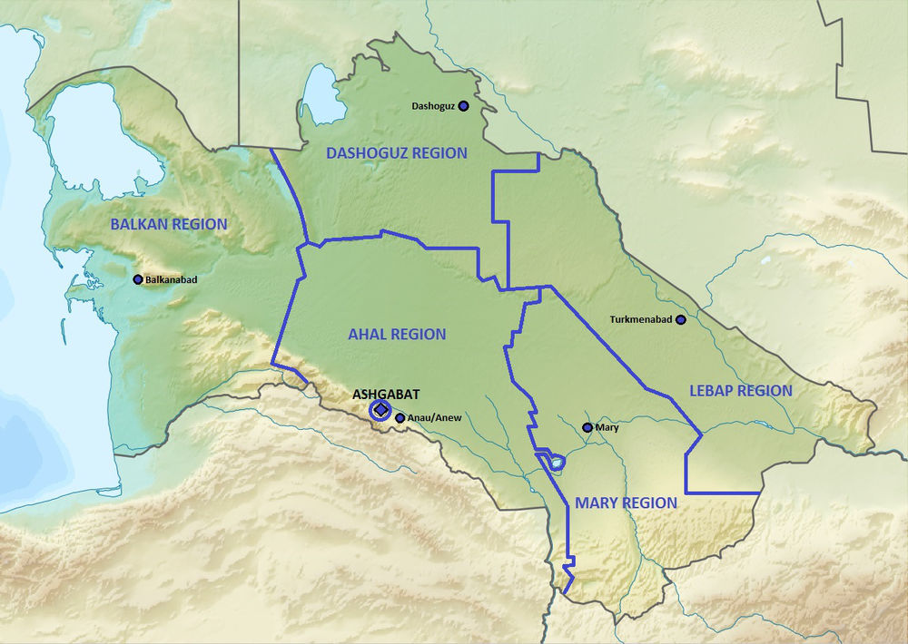
Turkmenistan (formerly known as Turkmenia) is a sovereign state in Central Asia, bordered by Kazakhstan to the northwest, Uzbekistan to the north and east, Afghanistan to the southeast, Iran to the south and southwest, and the Caspian Sea to the west. Ashgabat is the capital and largest city.
Turkmenistan has been at the crossroads of civilizations for centuries. In medieval times, Merv was one of the great cities of the Islamic world and an important stop on the Silk Road, a caravan route used for trade with China until the mid-15th century. Annexed by the Russian Empire in 1881, Turkmenistan later figured prominently in the anti-Bolshevik movement in Central Asia. In 1925, Turkmenistan became a constituent republic of the Soviet Union, Turkmen Soviet Socialist Republic (Turkmen SSR); it became independent upon the dissolution of the Soviet Union in 1991.
Turkmenistan possesses the world’s sixth largest reserves of natural gas resources. Most of the country is covered by the Karakum (Black Sand) Desert. Since 1993, citizens have been receiving government-provided electricity, water and natural gas free of charge.
Turkmenistan was ruled by President for Life Saparmurat Niyazov (also known as Turkmenbashi) until his death in 2006. Gurbanguly Berdimuhamedow was elected president in 2007. According to Human Rights Watch, „Turkmenistan remains one of the world’s most repressive countries. The country is virtually closed to independent scrutiny, media and religious freedoms are subject to draconian restrictions, and human rights defenders and other activists face the constant threat of government reprisal.“ After suspending the death penalty, the use of capital punishment was formally abolished in the 2008 constitution.
Historically inhabited by the Indo-Iranians, the written history of Turkmenistan begins with its annexation by the Achaemenid Empire of Ancient Iran. In the 8th century AD, Turkic-speaking Oghuz tribes moved from Mongolia into present-day Central Asia. Part of a powerful confederation of tribes, these Oghuz formed the ethnic basis of the modern Turkmen population. In the 10th century, the name „Turkmen“ was first applied to Oghuz groups that accepted Islam and began to occupy present-day Turkmenistan. There they were under the dominion of the Seljuk Empire, which was composed of Oghuz groups living in present-day Iran and Turkmenistan. Turkmen soldiers in the service of the empire played an important role in the spreading of Turkic culture when they migrated westward into present-day Azerbaijan and eastern Turkey.
In the 12th century, Turkmen and other tribes overthrew the Seljuk Empire. In the next century, the Mongols took over the more northern lands where the Turkmens had settled, scattering the Turkmens southward and contributing to the formation of new tribal groups. The sixteenth and eighteenth centuries saw a series of splits and confederations among the nomadic Turkmen tribes, who remained staunchly independent and inspired fear in their neighbors. By the 16th century, most of those tribes were under the nominal control of two sedentary Uzbek khanates, Khiva and Bukhoro. Turkmen soldiers were an important element of the Uzbek militaries of this period. In the 19th century, raids and rebellions by the Yomud Turkmen group resulted in that group’s dispersal by the Uzbek rulers. According to Paul R. Spickard, „Prior to the Russian conquest, the Turkmen were known and feared for their involvement in the Central Asian slave trade.“
Russian forces began occupying Turkmen territory late in the 19th century. From their Caspian Sea base at Krasnovodsk (now Turkmenbashi), the Russians eventually overcame the Uzbek khanates. In 1881, the last significant resistance in Turkmen territory was crushed at the Battle of Geok Tepe, and shortly thereafter Turkmenistan was annexed, together with adjoining Uzbek territory, into the Russian Empire. In 1916 the Russian Empire’s participation in World War I resonated in Turkmenistan, as an anticonscription revolt swept most of Russian Central Asia. Although the Russian Revolution of 1917 had little direct impact, in the 1920s Turkmen forces joined Kazakhs, Kyrgyz, and Uzbeks in the so-called Basmachi Rebellion against the rule of the newly formed Soviet Union. In 1924 the Turkmen Soviet Socialist Republic was formed from the tsarist province of Transcaspia. By the late 1930s, Soviet reorganization of agriculture had destroyed what remained of the nomadic lifestyle in Turkmenistan, and Moscow controlled political life. The Ashgabat earthquake of 1948 killed over 110,000 people, amounting to two-thirds of the city’s population.
During the next half-century, Turkmenistan played its designated economic role within the Soviet Union and remained outside the course of major world events. Even the major liberalization movement that shook Russia in the late 1980s had little impact. However, in 1990 the Supreme Soviet of Turkmenistan declared sovereignty as a nationalist response to perceived exploitation by Moscow. Although Turkmenistan was ill-prepared for independence and communist leader Saparmurad Niyazov preferred to preserve the Soviet Union, in October 1991 the fragmentation of that entity forced him to call a national referendum that approved independence. On December 26, 1991, the Soviet Union ceased to exist. Niyazov continued as Turkmenistan’s chief of state, replacing communism with a unique brand of independent nationalism reinforced by a pervasive cult of personality. A 1994 referendum and legislation in 1999 abolished further requirements for the president to stand for re-election (although in 1992 he completely dominated the only presidential election in which he ran, as he was the only candidate and no one else was allowed to run for the office), making him effectively president for life. During his tenure, Niyazov conducted frequent purges of public officials and abolished organizations deemed threatening. Throughout the post-Soviet era, Turkmenistan has taken a neutral position on almost all international issues. Niyazov eschewed membership in regional organizations such as the Shanghai Cooperation Organisation, and in the late 1990s he maintained relations with the Taliban and its chief opponent in Afghanistan, the Northern Alliance. He offered limited support to the military campaign against the Taliban following the 11 September 2001 attacks. In 2002 an alleged assassination attempt against Niyazov led to a new wave of security restrictions, dismissals of government officials, and restrictions placed on the media. Niyazov accused exiled former foreign minister Boris Shikhmuradov of having planned the attack.
Between 2002 and 2004, serious tension arose between Turkmenistan and Uzbekistan because of bilateral disputes and Niyazov’s implication that Uzbekistan had a role in the 2002 assassination attempt. In 2004 a series of bilateral treaties restored friendly relations. In the parliamentary elections of December 2004 and January 2005, only Niyazov’s party was represented, and no international monitors participated. In 2005 Niyazov exercised his dictatorial power by closing all hospitals outside Ashgabat and all rural libraries. The year 2006 saw intensification of the trends of arbitrary policy changes, shuffling of top officials, diminishing economic output outside the oil and gas sector, and isolation from regional and world organizations. China was among a very few nations to whom Turkmenistan made significant overtures. The sudden death of Niyazov at the end of 2006 left a complete vacuum of power, as his cult of personality, compared to that of former president Kim Il-sung of North Korea, had precluded the naming of a successor. Deputy Prime Minister Gurbanguly Berdimuhamedow, who was named interim head of government, won the special presidential election held in early February 2007. He was re-elected in 2012 with 97% of the vote.
The Turkmen people have traditionally been nomads and equestrians, and even today after the fall of the USSR attempts to urbanize the Turkmens have not been very successful. They never really formed a coherent nation or ethnic group until they were forged into one by Joseph Stalin in the 1930s. Rather they are divided into clans, and each clan has its own dialect and style of dress. Turkmens are famous for making Turkmen rugs, often mistakenly called Bukhara rugs in the West. These are elaborate and colorful rugs, and these too help indicate the distinction between the various Turkmen clans.
The Turkmens are Sunni Muslims but they, like most of the region’s nomads, adhere to Islam rather loosely and combine Islam with pre-Islamic animist spirituality. The Turkmens do indeed tend to be spiritual but are by no means militantly religious.
A Turkmen can be identified anywhere by the traditional „telpek“ hats, which are large black sheepskin hats that resemble afros. Traditional dressing for men usually consists of high, shaggy sheepskin hats and red robes over white shirts. Women wear long sack-dresses over narrow trousers (the pants are trimmed with a band of embroidery at the ankle). Female headdresses usually consist of silver jewelry. Bracelets and brooches are set with semi-precious stones.
Language
Outside the capital, the national language of Turkmen is the most widely encountered. In Ashgabat, it would be hard to find a person who did not speak Russian, however with recent efforts to revive the ancient culture of Turkmenistan, Turkmen is quickly regaining its place as the chief language of the state.
Turkmenistan flora includes thousands of species of plants, ranging from desert grasses and saksauls to mountain forests. The fauna is presented with the species of 91 mammals, 372 birds, 74 reptiles and 60 fishes. While flora and fauna are poorly represented in the desert, then the mountain river valleys are true wealth of Turkmen nature. All this wealth is protected by the Badkyz, Krasnodar and Repetek Reserves.
 The Turkmenistan climate is strongly continental. Daytime temperatures are very different: the average temperature in July of +30-32°С lowers to -5°С in winter. The average annual rainfall varies from 80 mm in the deserts to 400 mm in the mountains. At the same time the plains feature frequent hot winds and dust storms.
Most tourists are attracted to Turkmenistan by the unique natural landmarks: tremendous flora – forests of wild fruit and nuts trees, juniper forests on mountain slopes, pistachio savanna forests, saxaul forests, flood-plain tugais; diverse fauna – Central Asian leopards, argalis, koulans, goitered gazelles; enchanting sceneries – from picturesque mountain ridges to lifeless desert sands, from green oases to multikilometer sea coast.
Turkmenistan is famous for its caves. The most known of them are the Karlyuk caves. They are located on the slope of Kugitangtau Ridge and are considered unique natural sanctuaries, the are equal to none in entire Eurasia; they are by right included in the List of the World Legacy of UNESCO.
The Karlyuk caves are typical representation of various karst forms. There have been found around 60 caves with total length of 50 km, with galleries, passages, halls, labyrinths.
The caves are rich in wandering formations of plaster, calcite, aragonite in the form of stalactites, stalagmites, stone curtains etc. A lot of caves have not been explored yet.
In the west of Turkmenistan there are about 30 mud volcanoes. They are of various forms and exteriors. Periodically they throw up a mixture of mud masses, gases, waters and oil on the surface. The biggest volcano is called Aligul (extinct). The most ancient is the Boyadag mud volcano
Kara Kum Desert
Barchans the Kara Kum sands occupy 7 % of flat territories and are a characteristic form of sandy relief. They occur in places lacking of vegetation.
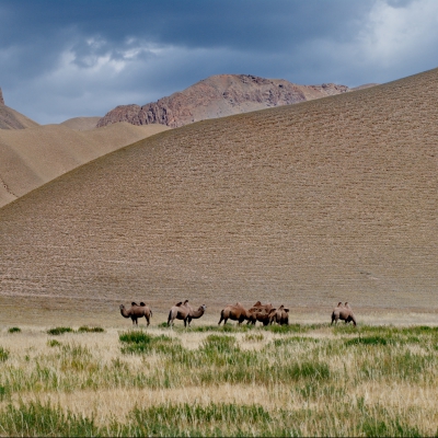
The Karakum is a sand desert stretching for 350,000 km2 from the Caspian Sea to Pamir foothills and from Amu Darya to Kopet Dag ridge. Its name is translated as “black sands” (“kara” – black, “kum” – sand). The dessert corresponds to its gloomy name, because some of its parts were previously completely waterless for hundreds of kilometers, and anyone who tried to cross it, found a terrible death under the scorching sun of Asia.
Structurally, the Karakum is a rugged plain with sand ridges and dunes connected with small salt marshes and takyrs. It is divided into the Zaunguz Karakum, located on a plateau, the Central Karakum, spread in the lowlands, and South-Eastern Karakum, gradually developing into the Kugitangtau foothills.
There is practically no surface water in the form of oases, but large volumes of groundwater, hidden beneath the sands, has a discharge through dug wells. Besides, the desert is crossed by the huge Karakum Canal, which takes water from the Amu Darya and carries it away almost for 1,000 km to the desert. In addition, in the south, there are several rivers flowing down from the mountains and dissolving in the sands.
The Karakum climate is very severe. Summer temperature can reach +50°С, while the soil can run hot as high as +80°С. Winter features strong frosts up to -30°С. Rainfall is very scanty, and precipitates mainly in November and April.
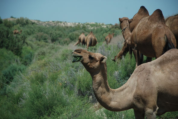
Flora is represented by the sand sedge, acacia, saksaul, and in spring, by grasses and flowers which cover huge areas, except for dunes, and completely dry up by May. Fauna of the Karakum desert includes gazelles, foxes, wolves, various rodents, lizards, snakes and insects. Besides the wildlife, grassland farming to raise sheep and camels is also common there.
Flora
Flora of Turkmenistan is made of relic forests, subtropics with a set of rare plants, picturesque nooks with preserved centuries-old vegetation.
More than 2.5 thousand plant species grow on the territory of Turkmenistan including about 700 ones in the Kara Kum Desert. Among the most precious plants is 2,000-thousand-old juniper (Turkmen archa) growing on inaccessible tops of the Kopet Dagh. The unique country’s grove called Unabi (Kugitang) has the trees whose age exceeds 200 years.
In Karakala, in Ajdere gorge grows the well-known 500-year-old Shakhoz (King of Nuts). Another unique nut grove is located in Ipaikala. Another attraction is the pistachio savanna Badkhyza with century-old trees on Kugitang. The savanna is unsurpassed in its beauty and rarity. In the foothills of the Kopet-Dagh grow about 1,700 kinds of plants – this is the largest „collection“ in Central Asia.
The desert flora is represented by the oldest black saxaul which has survived in Yeradzhin natural reserve.
Ashgabat
Ashgabat is a relatively young city, growing out of a village of the same name established by Russians in 1881. It is not far from the site of Nisa, the ancient capital of the Parthian Empire, and it grew on the ruins of the Silk Road city of Konjikala, which was first mentioned as a wine-producing village in 2nd century BCE and was leveled by an earthquake in 1st century BCE (a precursor of the 1948 Ashgabat earthquake). Konjikala was rebuilt because of its advantageous location on the Silk Road and it flourished until its destruction by Mongols in the 13th century CE. After that it survived as a small village until the Russians took over in the 19th century.
In 1869, Russian soldiers built a fortress on a hill near the village, and this added security soon attracted merchants and craftsmen to the area. Ashgabat remained a part of Persia until 1881, when it was ceded to Tsarist Russia under the terms of Akhal Treaty. Russia chose to develop Ashgabat as a regional center due to its proximity to the border of British-influenced Persia. It was regarded as a pleasant town with European style buildings, shops and hotels.
Soviet rule was established in Ashgabat in December 1917. However in July 1918 a coalition of Mensheviks, Social Revolutionaries and Tsarist former officers of the Imperial Russian Army revolted against the Bolshevik rule emanating from Tashkent and established the Ashkhabad Executive Committee. After receiving some support (but even more promises) from General Malleson, the British withdrew in April 1919, and the Tashkent Soviet resumed control of the city and in July 1919, when the city was renamed Poltoratsk (Полторацк) after a local revolutionary. The name Ashgabat was restored in 1927 after the establishment of Turkmen SSR as a Soviet republic, though it was usually known by the Russian form Ashkhabad. From this period onward, the city experienced rapid growth and industrialisation, although this was severely disrupted by a major earthquake on October 6, 1948. An estimated 7.3 on the Richter scale, the earthquake killed 110-176,000 (2/3 of the population of the city), although the official number announced by Soviet news was only 40,000.
Modern Ashgabat
Museums include the Turkmen Fine Arts Museum and Turkmen Carpet Museum, noted for their impressive collection of woven carpets as wellas a Turkmen history museum and the Ashgabat National Museum of History, which displays artifacts dating back to the Parthian and Persian civilizations. The Academy of Sciences of Turkmenistan is an important institute of higher learning.
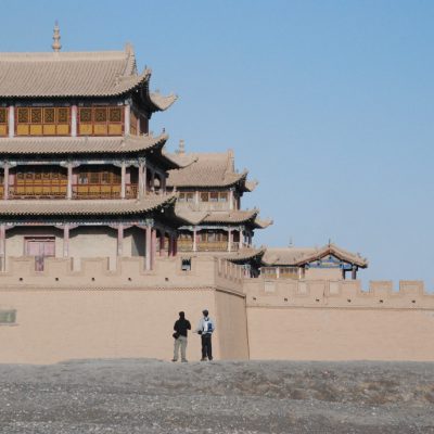
Large mosques include the Azadi Mosque (which resembles the Blue Mosque in Istanbul), the Khezrety Omar Mosque, and the futuristic Iranian Mosque. Ashgabat was also home to the Arch of Neutrality, a 250-foot-tall tripod crowned by a golden statue of late president Saparmurat Niyazov (also known as Turkmenbashi, or leader of all Turkmen). The 50-foot-high statue, which rotated in order to always face the sun during daylight hours, was removed on August 26, 2010 after Niyazov’s successor, current President Gurbanguly Berdimuhamedov, made it clear earlier in the year that the statue was going to be taken out of Ashgabat’s parliament square.
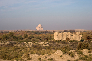
Merv, formerly Achaemenid Satrapy of Margiana, and later Alexandria and Antiochia in Margiana, was a major oasis-city in Central Asia, on the historical Silk Road, located near today’s Mary in Turkmenistan. Several cities have existed on this site, which is significant for the interchange of culture and politics at a site of major strategic value. It is claimed that Merv was briefly the largest city in the world in the 12th century. The site of ancient Merv has been listed by UNESCO as a World Heritage Site.
Merv
Merv consists of a few discrete walled cities very near to each other, each of which was constructed on uninhabited land by builders of different eras, used, and then abandoned and never rebuilt. Four walled cities correspond to the chief periods of Merv’s importance: the oldest, Erkgala, corresponds to Achaemenid Merv, and is the smallest of the three. Gäwürgala, which surrounds Erkgala, comprises the Hellenistic and Sassanian metropolis and also served as an industrial suburb to the Abbasid/Seljuk city, Soltangala – by far the largest of the three. The smaller Timurid city was founded a short distance to the south and is now called Abdyllahangala. Various other ancient buildings are scattered between and around these four cities; all of the sites are preserved in the “Ancient Merv Archaeological Park” just north of the modern village of Baýramaly and thirty kilometers west of the large Soviet-built city of Mary (Herrmann 1993).
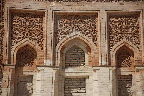
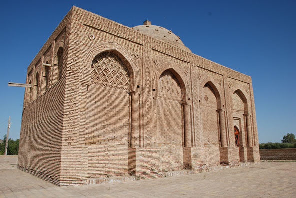
The best-preserved of all the structures in Merv is the 12th-century mausoleum of Sultan Sanjar. It is the largest of Seljuk mausoleums and is also the first dated mosque-mausoleum complex, a form which was later to become common. It is square, 27 meters per side, with two entrances on opposite sides; a large central dome supported by an octagonal system of ribs and arches covers the interior. The dome’s exterior was turquoise, and its height made it quite imposing; it was said that approaching caravans could see the mausoleum while still a day’s march from the city. The mausoleum’s decoration, in typical early Seljuk style, was conservative, with interior stucco work and geometric brick decoration, now mainly lost, on the outside. With the exception of the exterior decoration, the mausoleum is largely intact, and remains, just as is in the 12th century, Merv’s main tourist attraction.
Nisa
Nisa (also Parthaunisa) was an ancient city, located near modern-day Bagir village, 18 km northwest of Ashgabat, Turkmenistan. Nisa isdescribed by some as one of the first capitals of the Parthians. It was traditionally founded by Arsaces I (reigned c. 250 BC–211 BC), and was reputedly the royal necropolis of the Parthian kings, although it has not been established that the fortress at Nisa was either a royal residence or a mausoleum.
Excavations at Nisa have revealed substantial buildings, mausoleums and shrines, many inscribed documents, and a looted treasury. Many Hellenistic art works have been uncovered, as well as a large number of ivory rhytons, the outer rims (coins) decorated with Iranian subjects or classical mythological scenes.
Nisa was later renamed Mithradatkirt („fortress of Mithradates“) by Mithridates I of Parthia (reigned c. 171 BC–138 BC).
Nisa was totally destroyed by an earthquake, which occurred during the first decade BC.
The fortress at Nisa was declared a World Heritage Site by UNESCO in 2007.
Konye Urgench
Konye-Urgench is a municipality of about 30,000 inhabitants in north-eastern Turkmenistan, just south from its border with Uzbekistan. It is the site of the ancient town of Ürgenç (Urgench), which contains the unexcavated ruins of the 12th-century capital of Khwarezm. Since 2005, the ruins of Old Urgench have been protected by UNESCO as a World Heritage Site.
Formerly situated on the Amu-Darya River, Old Ürgenç was one of the greatest cities on the Silk Road. Its foundation date is uncertain, but the extant ruins of the Kyrkmolla fortress have been dated (rather ambitiously) to the Achaemenid period. The 12th and early 13th centuries were the golden age of Ürgenç, it became the capital of Khorezm Empire and it surpassed in population and famed all other Central Asian cities barring Bukhara. In 1221, Genghis Khan razed it to the ground in one of the bloodiest massacres in human history.
The city was revived after Genghis’s assault, but the sudden change of Amu-Darya’s course to the north and the town’s destruction again in the 1370s, this time by Timur, forced the inhabitants to leave the site forever.
The area was later inhabited by Turkmen in 1831, but they built outside the old town, using it as a graveyard.
A new town of Urgench was developed to the Southeast, in present-day Uzbekistan. First archeological research on the old city site was conducted by Alexander Yakubovsky in 1929.
Most of Ürgenç’s monuments have completely or partly collapsed. Nowadays, the site contains three small mausoleums of the 12th century and the more elaborate 14th-century Törebeg Hanym Mausoleum, which was much restored in the 1990s.
The most striking extant landmark of Old Urgench is the early 11th-century Gutluk-Temir Minaret, which, at 60 meters, used to be the tallest brick minaret prior to the construction of the Minaret of Jam – which was later surpassed by the Qutb Minar when it was completed in 1368. Also of note is the Il-Arslan Mausoleum – the oldest standing monument: a conical dome of 12 facets, housing the tomb of Mohammed II’s grandfather, Il-Arslan, who died in 1172. Somewhat to the north, sprawls a vast medieval necropolis.
Richtungen
Finden Sie mehr Informationen über die Länder der großen Seidenstraße
Browse tour by Activity
Subscribe to newsletter
Best price guarantee
Book a tour of your dream
Award winning
Best tour company in Kyrgyzstan
SECURE PAYMENT
Pay four tour online