
 Русский
 Español
 Français
 Deutsch


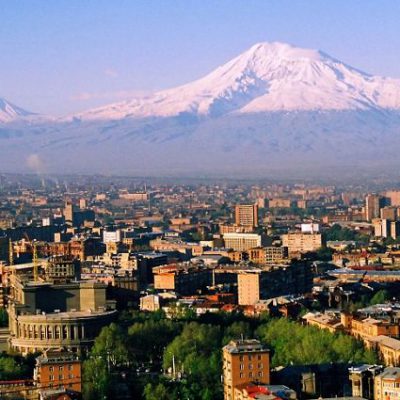


Kazakhstan
Kazakhstan is the world’s largest landlocked country and the tenth largest in the world, with an area of 2,724,900 square kilometers. Kazakhstan is the dominant nation of Central Asia economically, generating 60% of the region’s GDP, primarily through its oil/gas industry. It also has vast mineral resources. Some argue that Kazakhstan may be considered a European country because Kazakhstan’s Western region is on the European continent and meets the Council of Europe’s criteria for European inclusion.
Kazakhstan is officially a democratic, secular, unitary, constitutional republic with a diverse cultural heritage. Kazakhstan shares borders with Russia, China, Kyrgyzstan, Uzbekistan, and Turkmenistan, and also adjoins a large part of the Caspian Sea. The terrain of Kazakhstan includes flatlands, steppe, taiga, rock canyons, hills, deltas, snow-capped mountains, and deserts. Kazakhstan has an estimated 18 million people as of 2014. Given its large land area, its population density is among the lowest, at less than 6 people per square kilometer (15 people per sq. mi.). The capital is Astana, where it was moved in 1997 from Almaty, the country’s largest city.
The territory of Kazakhstan has historically been inhabited by Turkic nomads who trace their ancestry to many Turkic states such as Turkic Khaganate etc. In the 13th century, the territory joined the Mongolian Empire under Genghis Khan. By the 16th century, the Kazakh emerged as a distinct group, divided into three jüz (ancestor branches occupying specific territories). The Russians began advancing into the Kazakh steppe in the 18th century, and by the mid-19th century, they nominally ruled all of Kazakhstan as part of the Russian Empire. Following the 1917 Russian Revolution, and subsequent civil war, the territory of Kazakhstan was reorganized several times. In 1936, it was made the Kazakh Soviet Socialist Republic, part of the Soviet Union.
Kazakhstan was the last of the Soviet republics to declare independence during the dissolution of the Soviet Union in 1991. The current President, Nursultan Nazarbayev, has been leader of the country since then, and is characterized as authoritarian, with a government history of human rights abuses and suppression of political opposition. Kazakhstan has worked to develop its economy, especially its dominant hydrocarbon industry. Human Rights Watch says that “Kazakhstan heavily restricts freedom of assembly, speech, and religion,” and other human rights organizations regularly describe Kazakhstan’s human rights situation as poor.
Kazakhstan’s 131 ethnicities include Kazakhs (63% of the population), Russians, Uzbeks, Ukrainians, Germans, Tatars, and Uyghurs. Islam is the religion of about 70% of the population, with Christianity practiced by 26%. Kazakhstan officially allows freedom of religion, but religious leaders who oppose the government are suppressed. The Kazakh language is the state language, and Russian has equal official status for all levels of administrative and institutional purposes. Kazakhstan is a member of the United Nations, WTO, CIS, the Eurasian Economic Union, CSTO, SCO, OSCE, OIC, and TURKSOY.
Geography of Kazakhstan
As it extends across both sides of the Ural River, considered the dividing line with the European continent, Kazakhstan is one of only two landlocked countries in the world that has territory in two continents (the other is Azerbaijan).
With an area of 2,700,000 square kilometers (1,000,000 sq mi) – equivalent in size to Western Europe – Kazakhstan is the ninth-largest country and largest landlocked country in the world. While it was part of the Soviet Union, Kazakhstan lost some of it`s territory to China’s Xinjiang autonomous region and some to Uzbekistan’s Karakalpakstan autonomous republic.
The Kazakh Steppe of part of the Eurasian Steppe Belt.
It shares borders of 6,846 kilometres (4,254 mi) with Russia, 2,203 kilometres (1,369 mi) with Uzbekistan, 1,533 kilometres (953 mi) with China, 1,039 kilometres (653 mi) with Kyrgyzstan, and 379 kilometres (235 mi) with Turkmenistan. Major cities include Astana, Almaty, Karagandy, Shymkent, Atyrau, and Oskemen. It lies between latitudes 40° and 56° N, and longitudes 46° and 88° E. While located primarily in Asia, a small portion of Kazakhstan is also located west of the Urals in Eastern Europe.
Kazakhstan’s terrain extends west to east from the Caspian Sea to the Altay Mountains and north to south from the plains of Western Siberia to the oases and deserts of Central Asia. The Kazakh Steppe (plain), with an area of around 804,500 square kilometres (310,600 sq mi), occupies one-third of the country and is the world’s largest dry steppe region. The steppe is characterised by large areas of grasslands and sandy regions. Major seas, lakes and rivers include the Aral Sea, Lake Balkhash and Lake Zaysan, the Charyn River and gorge and the Ili, Irtysh, Ishim, Ural and Syr Darya rivers.
History of Kazakhstan
Kazakhstan is the largest country of the Eurasian Steppe, has been a historical “crossroads” and home to numerous different peoples, states and empires throughout history.
Human activity in the region began with the extinct Pithecanthropus and Sinanthropus one million–800,000 years ago in the Karatau Mountains and the Caspian and Balkhash areas. Neanderthals were present from 140,000 to 40,000 years ago in the Karatau Mountains and central Kazakhstan. Modern Homo sapiens appeared from 40,000 to 12,000 years ago in southern, central, and eastern Kazakhstan. After the end of the last glacial period (12,500 to 5,000 years ago), human settlement spread across the country and led to the extinction of the mammoth and the woolly rhinoceros. Hunter-gatherer communes invented bows and boats, and used domesticated wolves and traps for hunting.
The change of climate forced the massive relocation of populations in and out of the steppe belt. The dry period, which lasted from the end of the second millennium to the beginning of the 1st millennium BCE caused the depopulation of the arid belts and river-valley oasis areas; the populations of these areas moved north to the forest steppe.
Following with the end of the arid period at the beginning of the first millennium BCE, nomadic populations migrated into Kazakhstan from the west and the east, repopulating abandoned areas. These included several Indo-European tribes, often known collectively as the Scythians.
During the fourth century CE the Huns controlled Kazakhstan, absorbing 26 independent territories and uniting a number of steppe and forest peoples into a single state. Huns migrated west. Future of Kazakhstan was absorbed into the Turkic Kaganate and successor states.
Several independent states flourished in Kazakhstan during the Early Middle Ages; the best-known were the Kangar Union, the Oghuz Yabgu State, and the Karakhanid Kaganate.
In the 13th century, Kazakhstan was under the dominion of the Mongol Empire, and remained in the sphere of Mongol successor states for 300 years. Portions of the country began to be annexed by the Russian Empire in the 16th century, the remainder gradually absorbed into Russian Turkestan beginning in 1867. The modern Republic of Kazakhstan became a political entity during the 1930`s Soviet subdivision of Russian Turkestan.
Theorized proportion of Mongoloid elements in ancient and contemporary Kazakh populations, based on male craniological date.
Humans have inhabited Kazakhstan since the Lower Paleolithic, generally pursuing the nomadic pastoralism for which the region’s climate and terrain are suitable. Prehistoric Bronze Age cultures which extended into the region include the Srubna, Afanasevo, and Andronovo. Between 500 BC and 500 AD Kazakhstan was home to Saka and Huns, early nomadic warrior cultures.
Culture of Kazakhstan
Kazakhstan has a well-articulated culture based on the nomadic pastoral economy of the inhabitants.
Because of animal husbandry was central to the Kazakhs’ traditional lifestyle, most of their nomadic practices and customs relate in some way to livestock. Traditional curses and blessings invoked disease or fecundity among animals, and good manners required that a person ask first about the health of a man’s livestock when greeting him and only afterward inquire about the human aspects of his life.
The traditional Kazakh dwelling is the yurt, a tent consisting of a flexible framework of willow wood covered with varying thicknesses of felt. The open top permits smoke from the central hearth to escape; temperature and draft can be controlled by a flap that increases or decreases the size of the opening. A properly constructed yurt can be cooled in summer and warmed in winter, and it can be disassembled or set up in less than an hour. The interior of the yurt has ritual significance; the right side is generally reserved for men and the left for women. Yurts are also frequently used as a decoration in restaurants and other public buildings.
Almaty city
Almaty, also known by its former names Verny (Russian: “Faithful,” prior to 1921) and Alma- Ata (between 1921 and 1992), is the former capital of Kazakhstan and the nation’s largest city, with a population of 1 806 833 (as of January 1, 2018). This represents approximately 9% of the population of the country.
It is already more than 15 years since the capital has been moved from mild and soft climate of North Tian Shan into the cold and windy prairie of Central Kazakhstan. In spite of everything, Almaty is still the biggest city in the country and its main commercial, financial, scientific and educational center.
Aisha Bibi mausoleum
Aisha Bibi Mausoleum is an 11th or 12th century mausoleum for a noble woman located in the village of Aisha Bibi, 18 km west of Taraz town. It is locally famous as a monument to love and faithfulness.
Khoja Akhmed Yassawi
Khoja Akhmed Yassawi (born in Sayram in 1093, and died in 1166 in Hazrat-e Turkestan, both cities now in Kazakhstan), was a Turkic poetand Sufi (Muslim mystic), an early mystic, who exerted a powerful influence on the development of mystical orders throughout the Turkic-speaking world. Yasavi is currently the earliest known Turkic poet who composed poetry in a Turkic dialect.
Yassawi made considerable efforts to spread Islam throughout Central Asia and had numerous students in the region. Yasawi’s poems created a new genre of religious folk poetry in Central Asian Turkic literature and influenced many religious poets. Yassawi made the city of Yasi into the major centre of learning for the Kazakh steppes, then retired to a life of contemplation aged 63. He dug himself an underground cell where he spent the rest of his life. Turkish scholar Hasan Basri Çantay noted that “It was a Seljuk king who brought Rumi, the great Sufi poet, to Konya; and it was in Seljuq times that Ahmad Yesevi, another great Sufi, lived and taught. The influence of those two remarkable teachers has continued to the present.”
A mausoleum was later built on the site of his grave by Tamerlane the Great in the city (today called Turkistan).
Otrar
Otrar was first excavated in 1969. Remains were found of some brick structures, including a palace, mosque, a bathhouse and ovens. Otraror Utrar (also called Farab) is a Central Asian ghost town that was a city located along the Silk Road near the current town of Karatau in Kazakhstan. Otrar was an important town in the history of Central Asia, situated on the borders of settled and agricultural civilizations. It was the center of a great oasis and political district, commanding a key point connecting Kazakhstan with China, Europe, Near and Middle East, Siberia and Ural.
Kolsay lakes
Kolsai lakes are mountain lakes in the Northern Tien Shan. They are located down along the gorge of the Kolsai River in a peculiar cascade. The most available is the Lower Lake: a good dirt road comes to it.
The lake is located at an altitude of 1818 m, has a length of 1450 meters, a width of 400 meters and a depth of 80 m. It was formed as a result of the manifestation of seismic activity. A huge collapse from the western ridge formed a grand dam. Repeatedly the waters of the reservoir broke it, as a result of which a deep canyon formed below the lake. The landscape around the lake is very picturesque. All the slopes were densely covered with the famous Schrenk spruce, which grows only in this part of the planet. Rainbow trout lives in a pond. The lake in all seasons and at different times of the day is beautiful in its own way. Especially the lake is adorable in autumn, when the deciduous plants bloom with all the colors of the rainbow on the background of evergreen spruce trees.
The Second or Middle Lake is located higher along the gorge, at six and a half kilometers, at an altitude of 2,250 meters. The lake also formed as a result of a powerful earthquake and the collapse of the eastern slope. The lake has a length of one kilometer and a width of up to 550 meters and also a considerable depth. The western and northern slopes are covered with a thick spruce forest. The eastern slopes are alpine meadows with sparse islets of spruce forest. In the lake also lives rainbow trout.
The upper lake is located at a distance of four kilometers from the Middle Lake, at an altitude of 2,680 meters. After the retreat and melting of the ancient glacier, in which the lake was formed. An ancient moraine serves as a natural dam. The lake has a wrong form and smaller dimensions: 450 meters in length and 330 meters in width, the depth is unknown. The lake is located on the border of two zones – forest and alpine meadows. The forest here is not so thick as below, and immediately after the lake high-mountain meadows begin. The lake is absolutely lifeless and very cold.
Big Almaty Lake
Now this lake is known as Big Almaty, or BAO, called so not because of its size, but by the name of the gorge. In old times, bears the name Zhosalykol, i.e. “Ocherous”, because of the reddish color of the rocks Baby peak, bathing its slopes in its waters.
The lake is located at an altitude of 2511 meters. The Big Almaty Lake, together with the Issyk (1756 m) are the largest mountain lakes in the Zajlijskiy Alatau, only the BAO is located at a higher altitude.
The proposed reasons for the formation of the lake are two. The first of them is tectonic. About 2000 years ago there was a powerful earthquake, and a huge collapse blocked the gorge, creating a big natural dam, behind which a beautiful blue lake was formed. Affects the size of the dam – the height from the base to the upper ridge is 500 m, and the length along the river bed is 2.5 km.
The second reason is the activity of the ancient glacier. The glacier moved, pushing a huge mass of stones in front of it, forming a moraine. Grinded and deepened the hollow, then retreated, leaving the dam and the lake. The water of the lake is of high quality and is used for water supply in Almaty. In 1962 a cascade of hydroelectric power stations was built on the lake. The natural dam was raised by 10 meters and reinforced from the side of the lake with concrete slabs, equipped with a bottom outlet and an automatic spillway. At an average level of filling the lake reaches 1.5 km in length, up to 700 m in width.
The lake has an amazing game of water color: during the day it changes from azure and turquoise to a deep ultramarine. The lake is surrounded by the majestic peaks of the Trans-Ili Alatau, forming a kind of crown. In the locality of the lake there are several objects, which have a big scientific importance. On the dam there is a Special Solar Observatory and another Kazhydromet station. There is Tien Shan High-altitude Expedition of the State Astrophysical Institute, founded in 1957. Sternberg of the Moscow State University, which is now called – High-altitude Almaty station GAISH. There is also a frontier post, guarding the state border, passing along the ridge of the Trans-Ili Ala-Tau. To the west of the lake there is a serpentine road, which ends at the pass Zhosalykezen (3336m). There is another Tien Shan Scientific High-altitude station, which studies cosmic radiation, better known as Cosmostation.
Immediately there is another attraction, well visible from Alma-Ata, it is Great Almaty peak. The proud name is a toponymic incident associated with the name of the gorge, the height of the summit is only 3681 meters. But it is this mountain, which looks like the right pyramid from the side of the city, gives a unique color to the urban landscape.
Singing dunes
The wonderful phenomenon of nature is the Akkum-Kalkan sands, which was called “The Singing Barchan”. Sands, which in dry and windy weather sound like a highly flying jet plane. The power of sound is such that it spreads over many kilometers in the district. “Singing barkhan” is located in the natural park “Altyn Emel”, between the two ridges Kysty – Kalkan and Ulken – Kalkan.
Barhan was formed as a result of blowing sand from the banks of Ili River. A strong wind blows in this unit of Ili river valley (between the Kalkans and the Boguty and Sogety mountains), which raises clouds of sand dust from the river banks. At the Big and Small Kalkans, standing at a slight angle to each other, the wind meets barrier and, wanes and leaves sand. For many millennium rose sand mountain 150 meters high, 3 km long in the depth of the Ili Valley. The barkhan stays fixed for several millennium, in despite of fluctuation of sand and strong winds.
In strong winds, the barkhan begins to sound. The sound can be caused by quickly escaping or slipping in dry weather from the top of the barkhan. From the barkhan opens up a beautiful view of the surrounding locality. In the south you can see the glittering ribbon of the Ili River. On the horizon, in the haze, you can see the violet mountains of Sogety and Boguty. In the east and west, like the gates of a huge fortress, rise the Ulken-Kalkan and Kysty-Kalkan mountains. In the north, beyond the vast plain, there are a ridge of spurs of the Dzhungar Alatau, Mount Matai and Altyn-Emel.
Aktau mountains
The mountains of Aktau (in translation means “white mountains”) – this is another amazing nature corner of our country. This place is also called – geological museum under the open sky.
The mountains are located on the territory of the National Natural Park “Altyn Emel”. More than 60 million years ago the sea was splashing here. Frequent rains and mudflows washed the ground of surrounding mountains into it. Here it was deposited on the bottom with red, white, yellow clays. The thickness of the marine sediments exceeds 1800 m, the water washed in them hollows and deep gorges, and the wind helped the water transform the landscape. These lifeless slopes are fancifully rugged by erosion, so unusual that it is impossible to tear eyes. Landscapes change constantly – narrow gorges, bastions, towers, impregnable castles, there is no end to them.

Destinations
Find more information about the countries on the Great Silk Road
Browse tour by Activity
Subscribe to newsletter
Best price guarantee
Book a tour of your dream
Award winning
Best tour company in Kyrgyzstan
SECURE PAYMENT
Pay four tour online